Siirry pääsisältöön

Palvelut


3D scanning 


Laserkeilaus on tehokas menetelmä rakennuksen, tien tai maaston dokumentointiin ja digitointiin suurella tarkkuudella. Tarjoamme laserkeilausta monilta eri alustoilta ja olemme asiantuntijoita löytämään oikean ratkaisun asiakkaidemme tarpeisiin, yleensä yhdistelemällä eri skannausmenetelmiä. 

3D scanning


Project planning with high precision 

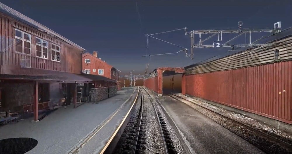
3D-laserskannaus on yksi tarkimmista käyttämistämme skannausmenetelmistä.

Laserskanneri on staattinen ja sitä siirretään manuaalisesti skannausasennosta toiseen, jolloin saadaan erittäin yksityiskohtainen pistepilvi RGB-väreillä ja 360-panoraamakuvilla.

Näin tarkat ja yksityiskohtaiset pistepilvet ovat ihanteellisia olemassa olevan tilanteen dokumentointiin.

Tätä menetelmää voidaan käyttää monin eri tavoin, kuten:   

  • As-rakennettu dokumentaatio
  • 2D-suunnitelmapiirustukset 
  • 3D-mallit (BIM), joissa on halutut yksityiskohdat. 
  • Visualisointi     
  • Analyysi 
  • 360 asteen panoraamakuvat


3D-laserskannaus


Maanpäällinen skannaus

Frequently asked questions:


What is 3D scanning?

3D scanning uses various types of sensors to reliably measure and record objects in three-dimensional space. The resulting point cloud of data provides accurate point clouds of interior environments, buildings, or structures. This is useful in architecture, engineering, and other fields for accurate documentation and analysis of indoor environments.

What accuracy do you need?

The accuracy you order has a lot to do with the price. In general, the higher the accuracy you need, the more it costs. Consider what you will use the result for. And choose the accuracy according to your needs. We are happy to help you make the right choice!

Revit, ArchiCAD, and IFC models?

All three are BIM (Building Information Models). Which one do you need? Check who will be working with the model and what they prefer to work in. An architect will often prefer an ArchiCAD model. Others will prefer a Revit model. And some will only want a 2D drawing. Be sure before you order. You can save a lot of time and money here. We can also help you figure out what you need!

Do you offer Google Street View?

Are you tired of traveling to the project to take measurements and check things that were forgotten during the inspection? We can scan and create a Google Street View of your project so you can take measurements and even operate the building from your PC, mobile phone, or tablet.

What does LOD mean?

In 3D scanning, LOD refers to different levels of detail that can be selected based on the needs and purpose of the model. Lower LODs can be used to represent general shapes and contours, while higher LODs provide more detailed information, including smaller details and textures.

How does 3D scanning improve quality control?

A 3D scan is excellent for checking that what has actually been built is in accordance with the drawings. We use 3D scans and compare them with the BIM model. This allows us to see what is within tolerances and what is outside them.


Rataverkon 3D-laserskannausmalli

Ota yhteyttä

Dagfinn solvik

Norja

Dagfinn Solvik-Olsen

Leder, Field Survey

+47 930 48 141

Sven Bratland

Norja

Sven Bratland

Regionsleder, Field Survey Bergen

+47 474 07 550

Lasse Turunen

Suomi

Lasse Turunen

Business Manager, Analytics & Software

+35 850 491 5180

Victor Kvarnström

Ruotsi

Victor Kvarnström

Regionsleder, Field Survey Göteborg

+46 (0)70 249 51 74


Maanmittaus_64x64

Maanmittaus

Maanmittauksella on ratkaiseva rooli useimpien infrastruktuuri- ja rakennushankkeiden suunnittelu- ja toteutusvaiheessa maailmanlaajuisesti. Maanmittaus varmistaa digitaalisten mallien ja fyysisen maailman välisen tarkkuuden. Maanmittaustekniikalla määritetään pisteiden tarkka maantieteellinen kolmiulotteinen sijainti sekä niiden väliset etäisyydet ja kulmat. Tiimillämme on laaja kokemus maanmittauspalvelujen tarjoamisesta hallituksille, yrityksille ja yksityishenkilöille pääasiassa Norjassa, mutta myös Ruotsissa ja Suomessa. Tutustu alla oleviin Field .

Paikkatietoratkaisut, jotka perustuvat ohjelmistoihin, sensoreihin ja tekoälyteknologioihin.

Liity joukkoomme ja auta keräämään ja muuntamaan tarkat paikkatiedot arvokkaiksi oivalluksiksi ja digitaalisiksi kaksosiksi.