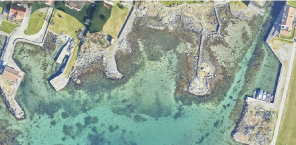
Palvelut
Bathymetric LiDAR is an advanced technique for capturing high‑resolution geospatial data of coastlines and shallow water environments, enabling fast, accurate, and efficient hydrographic mapping. LiDAR mapping is ideal for projects where traditional methods are time-consuming or limited.

Field has long and proven experience in LiDAR scanning beneath the water surface. Using state‑of‑the‑art airborne laser scanning systems and green laser technology, we capture seamless data across both land and water. Our expertise covers marine and freshwater environments, including coastal areas, lakes, and rivers.
Bathymetric LiDAR data is a key input for mapping hazards such as flooding, erosion, and landslides. It supports secure project planning, environmental monitoring, and decision‑making in river basins and coastal areas. The wide coverage and rapid data acquisition enable efficient surveys, even in shallow or hard‑to‑access zones.
In shallow coastal and beach zones, our data contributes to comprehensive terrain models that integrate topographic LiDAR with underwater depth data. We combine airborne LiDAR with sonar data from boat‑based systems to ensure continuous and consistent coverage from land to deeper water.
Processed data is delivered according to project needs, typically as digital terrain models or elevation contours, with orthophotos available as an additional product. To ensure optimal coverage and data quality, Field also performs complementary surveys using multibeam echo sounders in areas where airborne sensors are less effective.
With Field, you get reliable bathymetric data, efficient project execution, and complete environmental surveys and insights.
Helligværin saariston (Norja) batymetrinen LiDAR-kuvaus. Kartverketin omistamat tiedot.
Field on historiaa ilmakuvauksesta 1950-luvulta lähtien. Tarjoamme korkealaatuisia sensoripalveluja, jotka tuottavat tarkkaa tietoa digitaalisia tuotteita ja päätöksentekoa varten. Ainutlaatuinen osaamisemme ja ultramoderni lentokone- ja anturikalustomme pystyvät vastaamaan haastavimpiinkin projektivaatimuksiin. Meillä on oma miehittämättömien ilmakartoitusjärjestelmien linjamme, ja lisäksi teemme yhteistyötä paikallisten palveluntarjoajien kanssa maailmanlaajuisesti. Tutustu alla oleviin Field .
Liity joukkoomme ja auta keräämään ja muuntamaan tarkat paikkatiedot arvokkaiksi oivalluksiksi ja digitaalisiksi kaksosiksi.