Palvelut
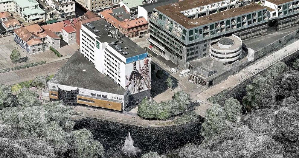
A point cloud is a highly detailed 3D representation of real-world environments made up of millions — sometimes billions — of individual measurement points. Each point contains precise spatial coordinates (X, Y, and Z), and often additional information such as intensity, color, or classification. At Field we deliver end-to-end point cloud solutions — from data acquisition to advanced analysis and deliverables.

Pistepilvet
Point clouds are typically generated using advanced technologies such as:
When combined, these individual points create an accurate, measurable digital replica of terrain, buildings, infrastructure, vegetation, and other physical features.
Field delivers Point cloud services that supports a wide range of industries and applications, including:
Because the data is measurable and spatially accurate, it becomes a powerful foundation for GIS, CAD, BIM, and digital twin workflows.
At Field, we leverage artificial intelligence to unlock the full potential of point cloud data. AI algorithms can automate and enhance tasks that are traditionally time-consuming, such as:
Classification - Automatically identifying ground, buildings, vegetation, roads, and other features
Object Detection - Detecting and mapping poles, power lines, vehicles, or construction equipment
Change Detection - Comparing point clouds over time to track construction progress, erosion, or land-use changes
Noise Removal & Data Cleaning - Quickly filtering out errors and irrelevant points
Predictive Modeling - Identifying patterns or potential risks in infrastructure or natural environments
Our team of geospatial specialists combines years of experience with cutting-edge AI-powered intelligence to deliver highly accurate point clouds and insights.
Get in touch if you would like more information.
Lentotietojen keruu, RGB-pistepilvi, laserkeilaus.
Field tarjoaa laajan valikoiman paikkatietokartoitus- ja tietopalveluja, kuten kaupunki- ja käytäväkartoituspalveluja, kaukokartoitukseen perustuvia metsien inventointipalveluja ja paikkatietopalveluja. Elämme digitaalisessa maailmassa, jossa fyysisen omaisuuden digitaalinen malli on standardi. Suunnittelu, rakentaminen ja ylläpito tehdään 3D:nä, mikä säästää kustannuksia ja lisää tehokkuutta. Meillä on laaja kokemus paikkatietojen käsittelystä kaupunkien, infrastruktuurin, rakennusten, maaston ja merenpohjan 3D-malleiksi. Tutustu alla oleviin Field ja mallinnuspalveluihin.
Liity joukkoomme ja auta keräämään ja muuntamaan tarkat paikkatiedot arvokkaiksi oivalluksiksi ja digitaalisiksi kaksosiksi.